Hasn’t hit us here yet in San Diego, and we will probably get the least severe weather, but this is a HUGE storm. Well a good Sierra snow pack will help our water situation at least.
If you’re in California this weekend, stay safe, warm and dry….
Wunder Blog : Weather Underground
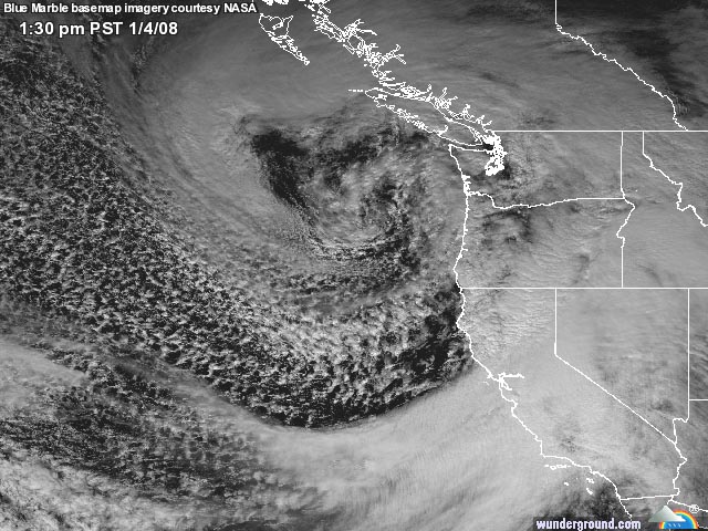
A mighty hurricane-force Pacific storm continues to clobber California with blizzards, damaging winds, and flooding rains. Hardest hit are the Sierra Mountains, where winds at Ward Mountain near Lake Tahoe were 86 mph, gusting to 163 mph, at 11 am PST. The storm responsible is visible just off the coast of Washington (Figure 1), and has a central pressure near 960 mb–similar to that of a Category 2 hurricane. Blizzard conditions will continue over much of the Sierras, with 2-5 feet likely to fall by Saturday. Travel will be difficult of impossible in the northern mountains of California Friday and Saturday. Snow amounts may reach 10 feet by Monday in some mountain regions of California.
Sunday UPDATE:
We didn’t get very much rain from this storm here in San Diego. Northern California got most of the high winds, snow and flooding. Heavy rains and a broken levee created flooding in one Nevada town. Here’s the latest from Wunderground:
Heavy snow, flash floods, and damaging winds continue to pound California today as a weakening Pacific storm moves inland over British Columbia. The winds have died down considerably in the Sierra Mountains, where hurricane force winds were common on Friday. The storm’s highest winds occurred at Ward Mountain near Lake Tahoe–sustained at 110 mph, gusting to 163 mph, on Friday. Prodigious snow amounts of up to six feet have fallen in the Sierras, with Blackcap Basin in Fresno County (elevation 10300 feet) reporting 71.3 inches (5.9 feet) of new snow as of 4 am PST Saturday. Continued heavy snows are expected in the Sierras through Sunday, with total amounts up to ten feet possible.
At lower elevations, heavy rain has triggered flash floods. In Chino Hills, just east of Los Angeles, a flash flood swept away a vehicle that had gone around a barricade. One occupant was found hypothermic and clinging to a tree, but the vehicle and its other occupant are missing. A mudslide forced the temporary closure of Interstate 15 nearby. Rain amounts exceeding ten inches (Figure 1) have fallen in the mountains of Central and Northern California, and in Nevada, heavy rains caused a levee to burst along the Truckee Canal in Fernley, flooding hundreds of homes.
8 Responses
[…] Changing Places [San Diego] […]
If the storm is headed for California, how come the weather map shows its eye poised to enter Puget Sound. Despite what Californians think, Washington and Oregon are not the two most northerly counties of the Golden State!
That’s just how big this storm was – the center is over Vancouver, but it’s pulled in so much moisture that the outer bands are raining right now in San Diego – yes, this is all one HUGE storm mass.
And that eye is reading 956 mb according to some of the weather junkies in Vancouver….
Hi Donna,
I’ve just read in the newspaper that you guys got like 3m of snow (90 ft?). Is that true? 😮
Well, not here, at least! The Sierra mountain range in northern California had about 5 ft of snow, maybe more in some spots. The storm was quite varied as it passed different places though – we didn’t get the high winds here or the flooding we were warned about, just nice gentle rainfall most of the day and night.
Today is starting out clear, beautiful and quite gorgeous, although we may still get some showers.
I hope it turns out ok for you guys!
PS: Had some good news: paid the tax, it’s off to the States 🙂
[…] California is getting a BIG storm! […]